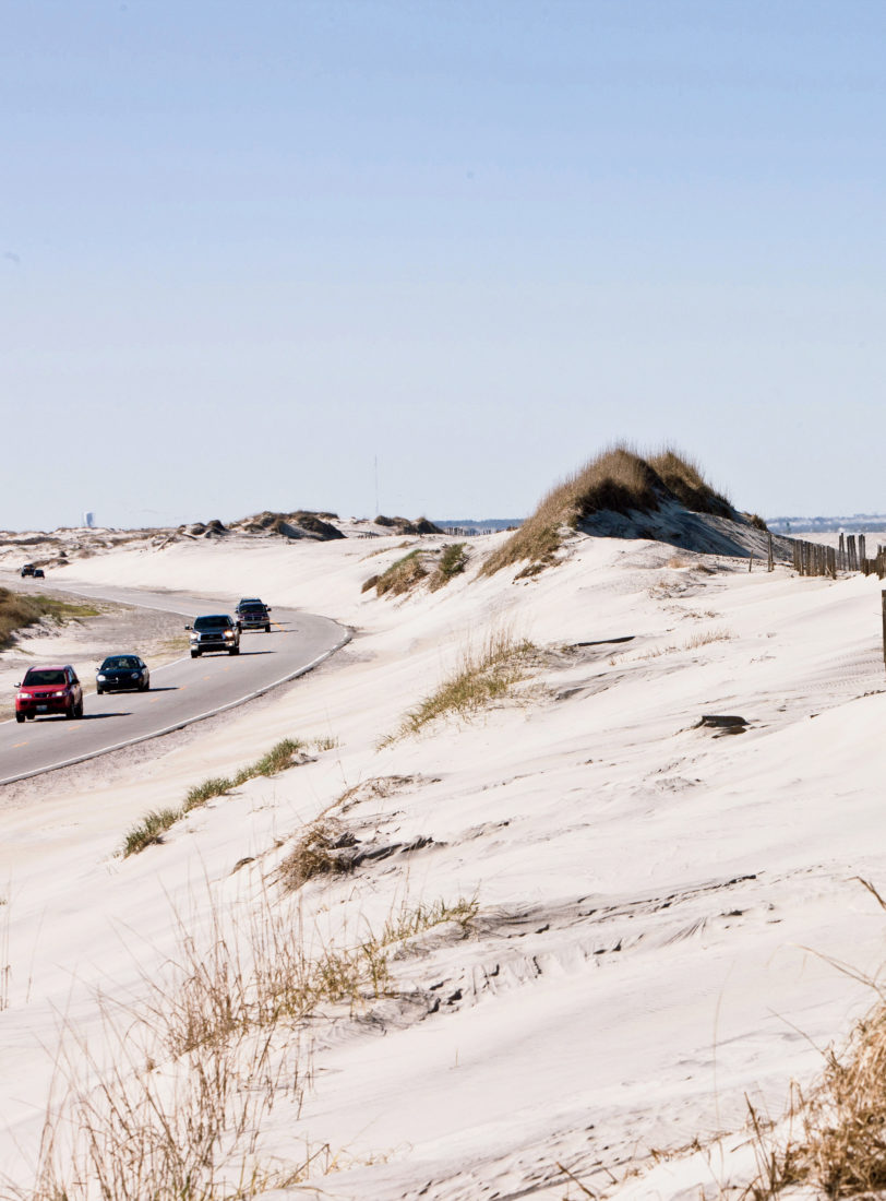
A narrow two-lane ribbon of asphalt, NC 12 winds its way across North Carolina’s Outer Banks, a slender string of isolated barrier islands that stand sentinel off the coast—in some places more than thirty miles from the mainland they protect. The historic roadway—it wasn’t paved until 1950—is flanked by lush tidal marshes and pristine sounds on one side and towering dunes, deserted beaches, and the wide-open Atlantic on the other. There are two national seashores, two national wildlife refuges, and four historic lighthouses. In between, you’ll find tiny maritime villages are anchored by locally owned businesses with hardly a chain in sight. Before summer chokes the path with eager vacationers, hit the road and discover the region’s unique history and heritage for yourself.

Distance: 103 miles
The route: Take U.S. 64 to Roanoke Island and across the sound to Nags Head where 64 dead ends onto the Outer Banks National Scenic Byway (NC 12), making a left towards Duck.
If you go:
There is a lot to see along the way, but be sure to plug these detour-worthy destinations into your GPS.
Duck: Hang a left where U.S. 64 runs into NC 12 and continue on to Duck, named for the waterfowl who stop over here. Bunk at the Sanderling Resort for the night, which butts up against a 2,600-acre Audubon preserve. A former hunting lodge, Sanderling got a major makeover in 2013. There are two new beachside pools, two renovated restaurants, and a spa. You can also rent bikes and pedal into the village for the afternoon. Before heading [south] towards Ocracoke in the morning, grab a coffee for the road and a paperback at Duck’s Cottage, housed in a 1920’s hunting cabin.

Sanderling Resort
Jockey’s Ridge State Park: To explore Jockey’s Ridge, veer off NC 12 in Nags Head and onto the Highway 158 bypass to reach the park’s entrance. At heights of eighty to a hundred feet, it’s the tallest active sand dune system on the East Coast. The towering mountains of sand—equal to some 6,000,000 dump trucks’ worth—are ever-changing but will never blow away (the prevailing northeast and southwest winds simply move the sand back and forth). If you’re a bit of an adrenaline junky, Kitty Hawk Kites offers lessons for Dune Hang Gliding.

Jockey’s Ridge State Park
Sam & Omie’s: Make like a local and fill up with the hearty two-egg breakfast—side of bacon or country ham, grits, and your choice of a biscuit or toast—at this Outer Banks landmark, located just across NC 12 from Jennette’s Pier in Nags Head. Opened more than seventy years ago by a local charter fisherman, Sambo Tillet, the no-fuss restaurant is still popular with the bait-and-tackle crowd, and is packed in the early mornings.
To wet a line, head to Oregon Inlet Fishing Center or Pirate’s Cove Marina to book a charter. The area is renowned for its superior sportfishing, and come early May, Mahimahi, and wahoo, will be biting. You can’t go wrong with any of the area fishing outfits but at OI try Fin-Planner or Bi-Op Sea. At Pirate’s Cove, Sea Toy is a good bet.

Oregon Inlet Fishing Center
Pea Island National Wildlife Refuge: Continue south on NC 12 and cross the Herbert C. Bonner Bridge over the Oregon Inlet. On the south side of the bridge, look for the refuge entrance sign on your right. Part of the Cape Hatteras National Seashore, the park’s thirteen miles of protected beach provide nesting areas for loggerhead sea turtles and all manner of shorebirds. With showier Peregrine falcons and bald eagles too, it’s an amateur ornithologist’s dream.
Rodanthe/Waves/and Salvo: Dubbed the tri-villages by locals, these three quiet communities offer exceptional water access. In many spots you have both beach and sound views. They offer plenty of secluded shore; perfect to soak up some sun or hunker down with a book. The tri-village beaches are managed by the Cape Hatteras National Seashore, and you can take your car on the beach—an OBX tradition. Secure a permit online.
Cape Point: There are no paved roads that lead all the way to Cape Point, which juts out into the Atlantic like a sharp elbow, meaning you generally need a 4×4 vehicle to reach this world-renowned surf fishing spot. You’ll find the access ramp just off NC 12 by the Cape Hatteras Lighthouse in Buxton. If you don’t have a 4×4 car or truck, you can hike to water’s edge if you don’t mind a bit of a walk—the beach is about a mile from where the pavement ends. For beachcombers, this stretch is prime shell hunting territory. Go after a storm for the best finds.

Cape Point
Hatteras Landing: Continue south to Hatteras Landing and hop a ferry to Ocracoke Island at the terminal next door. Ferries run 365 days a year from 5 AM to midnight. It’s about a 40-45 minute trip, and if you don’t want to wait in line, evening is the best time to go. Bonus: Sunset views.
Ocracoke Island: On what is one of the most remote islands in the Outer Banks, lifelong locals, called High Tiders or O’Cockers, still speak with an almost British-sounding brogue. Wander around the low-key fishing village’s historic district, full of shingle-style coastal cottages, American Craftsman, and late Victorian homes. Reserve a room at the centrally located Castle B&B, a gorgeous gabled inn overlooking Silver Lake. Rent one of the inn’s bikes to explore the rest of the village. A stop in Howard’s Pub and Raw Bar is all but a requirement.

Castle B&B
From Ocracoke, two ferries will return you to the mainland. Unless you’ve decided to hock it all and never return.
About those lighthouses you hear so much about…There are three within this trip’s range: Bodie Island Lighthouse, Cape Hatteras Lighthouse, and Ocracoke Lighthouse. The fourth is north of Duck in Currituck. Each historic tower is worth a climb.

Bodie Island Lighthouse